Walk this way! Did you know that White City has more than 12 kilometers of multi-use pathways woven throughout our community with another 9 kilometers on the way. There are plenty of opportunities for you to ditch the car or couch and bike, hike or run!
A multi-use pathway means a pathway that is used for pedestrian and bike traffic. It should be constructed in an area where it is evident that including a multi-use pathway will provide a connection to an existing or proposed pedestrian network.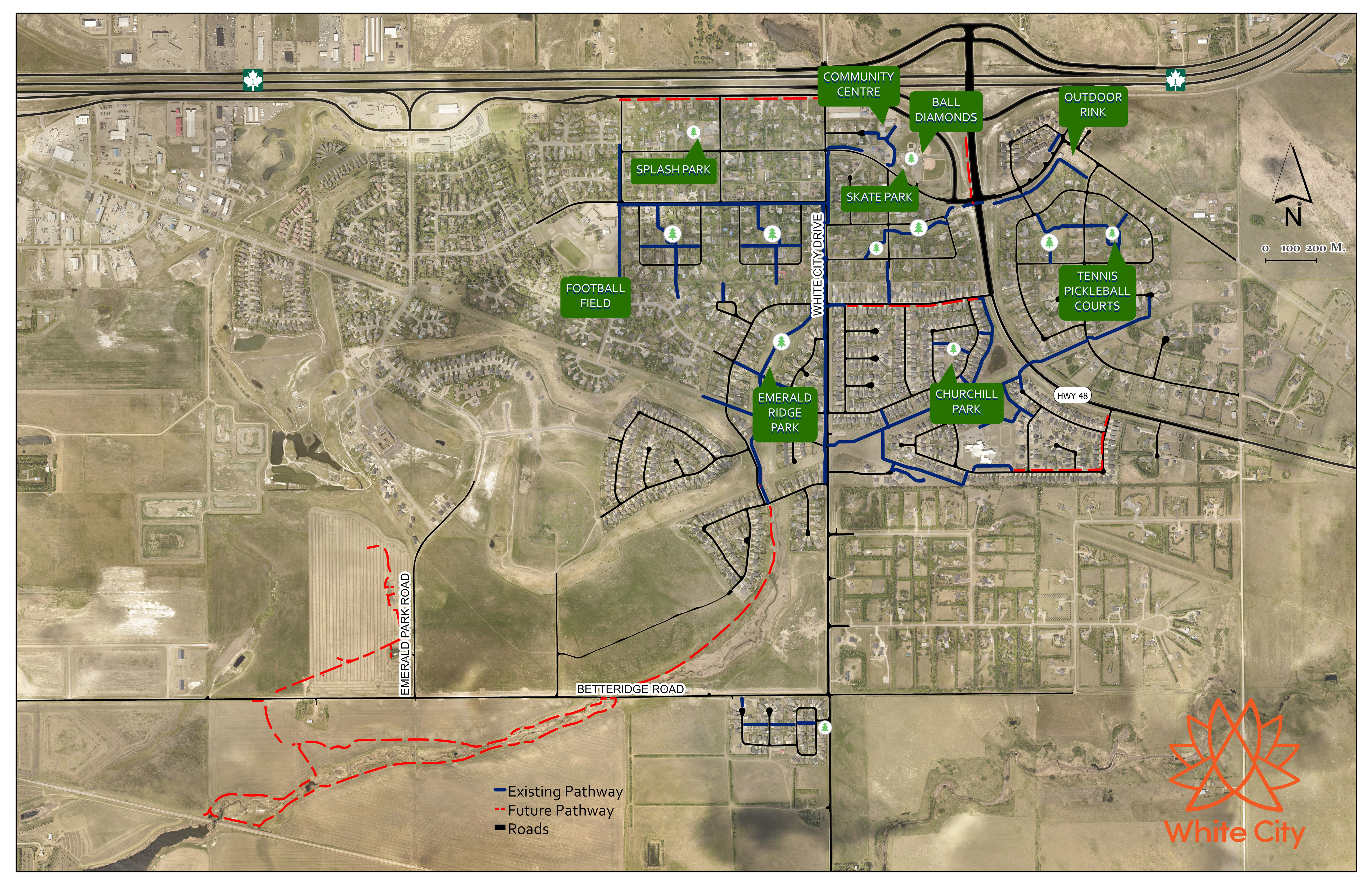
Our community has a mixture of residential and commercial development that has been developed with no sidewalks, curb, gutter or underground storm sewers. While this type of road is less expensive to construct and maintain, it can be a challenge for bicyclists and pedestrians. These development standards, along with recent growth in the community over the last 10 years, have led the Town to explore ways to improve pedestrian safety and ensure White City continues to be a bright, safe and healthy community.
In 2015, the Town commissioned a Traffic Study to help achieve the goal of improving pedestrian safety. One of the items reviewed in the Traffic Study was the Town’s pathway system. In response to this review, the Town implemented the Multi-Use Pathway Network Improvement project in 2019 to improve pedestrian safety in the community. This project aims to address multi-use pathway gaps and enhance pedestrian accessibility and mobility on existing streets that lack adequate infrastructure to support the pedestrian friendly environment of the Town of White City.
In 2016, the Transportation Advisory Committee (TAC) was created with a key responsibility of encouraging community dialogue on traffic and pedestrian safety issues affecting the Town, recommending traffic safety improvements and promoting the creation and adoption of projects and policies related to traffic and safety.
The assessment and evaluation of the municipal pathway system has been a focal point for the work of TAC. When evaluating the functionality of the municipal pathways system and the need for an improved pathway network, the committee focused on the following criteria:
- Location
- Safety
- Continuity & Integration
- Pedestrian Traffic
- Community Support
In addition, TAC evaluated selected roads within the Town’s transportation network for motor vehicle speed and pedestrian safety issues. Based on the above-mentioned criteria, the committee identified the following priorities for improvements to the Town’s pathway system:
Phase I – Lott Road East
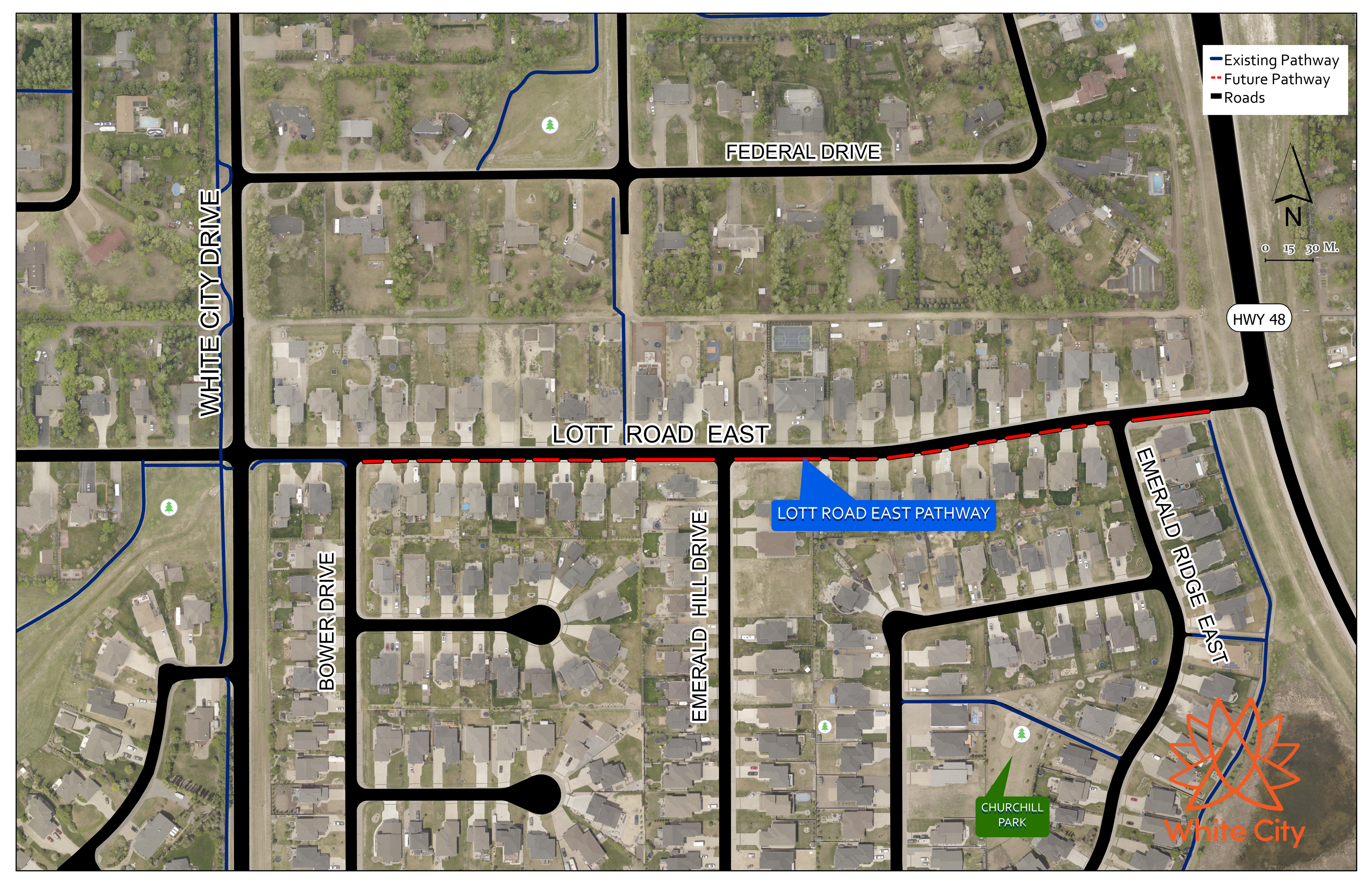
Lott Road East is an east-west municipal road that intersects Highway 48 approximately 380 metres south of Gregory Avenue. The connection of Lott Road East and Highway 48 was part of a subdivision application that was approved in February 2010 in association with the Bower West Phase I and II residential developments. This direct access to Highway 48 changes the function of Lott Road East into a collector roadway that provides access to Bower West and the remaining neighbourhoods throughout the Town.
Lott Road East reports traffic volumes that vary between 1,200 vehicles per day to 1,700 vehicles per day. This traffic volumes on Lott Road East are consistent with the characteristics of a typical collector road as outlined in the Transportation Association of Canada’s Characteristics of Urban Roads. While Lott Road East resembles a typical collector road in terms of traffic volumes and speeds, this section of road is densely populated and provides direct access to approximately 49 properties along the roadway. Furthermore, Lott Road East was designed with a 20-metre right of way and a 7.3 metre road surface, which is much narrower than a typical collector road, according to the Transportation Association of Canada’s Characteristics of Urban Roads.
As early as 2015, the residents of Lott Road East expressed numerous concerns related to pedestrian safety and sharing the road with vehicles since there are no pathways provided along the roadway. The speed limit along Lott Road East has been reduced from 50km/hr to 40km/hr and an all-way stop sign installed at the intersection with Emerald Hill Drive to reduce the speed of vehicles. After exploring several other traffic calming and pedestrian accommodation alternatives, the Traffic Study concluded that implementing a multi-use pathway adjacent to the south side of Lott Road East, would help improve pedestrian safety and connectivity.
In 2021, construction of the Lott Road East pathway was completed.
Phase II – Motherwell Drive
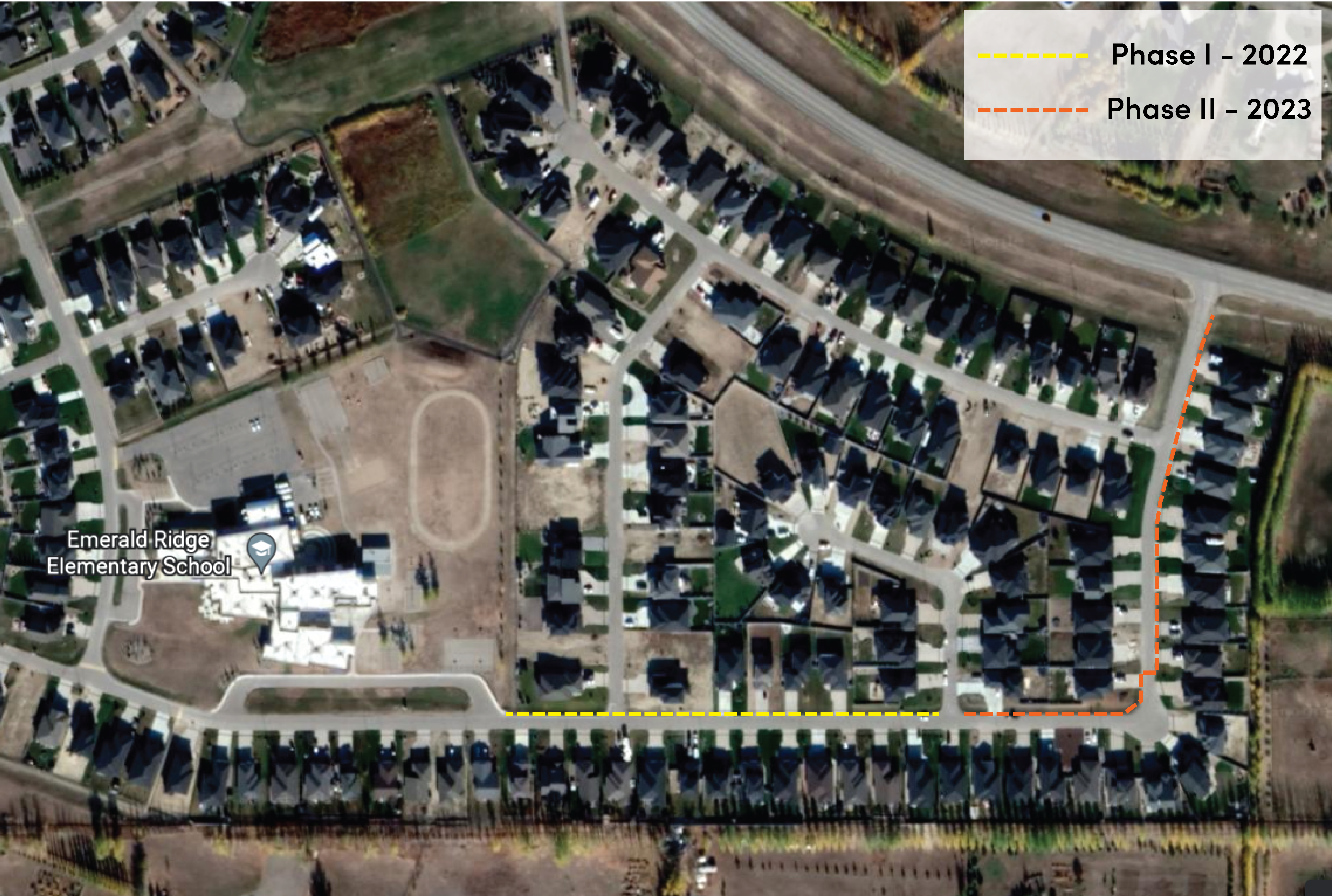 White City Town Council passed a resolution advancing the timeline for completion of a pathway along Motherwell Drive as part of the Multi-Use Pathway Network Improvement Project. The Motherwell Drive Pathway will now be completed as Phase II of the overall Multi-Use Pathway Improvement Project.
The project plan for this pathway will be completed in two phases:
Phase I - ERES to Yale Place (North Side of Road) - 2022
Phase II - Yale Place to Hwy 48 (North and East Side of Road) - 2023
As part of the approved Multi-Use Pathway Network Improvement Project, the Town of White City (Town) by recommendation from the Transportation Advisory Committee (TAC) has highlighted Motherwell Drive as a location that would greatly benefit from infrastructure improvements to support the pedestrian friendly environment of White City.
The Multi-Use Pathway Network Improvement Project is intended to address multi-use pathway gaps and enhance pedestrian accessibility/mobility on key existing arterial and collector streets. The locations included in this project show evidence that supports the addition of a pathway to provide a connection to an existing or proposed pedestrian network that will alleviate existing safety concerns.
The multi-use pathways have been provided in such a manner that they are located along several roadways which lead to key destinations such as Ecole White City School and Emerald Ridge Elementary School (ERES). There are several paths that connect ERES to the west of the Town but only one that provides a direct connection to the east of the Town. This is an at-grade crossing on Highway 48 connecting the pathway system east of the highway.
Although traffic volumes recorded in 2018 were lower than 1000 vehicles per day, it is anticipated that with the completion of Bower West Phase III, pedestrian traffic along Motherwell Drive has increased dramatically and with it the potential need of exclusive pedestrian facilities. This pathway will provide pedestrian connectivity along Motherwell Drive, from the existing pathways west and north of ERES to the east/north and a future connection pathway along Highway No. 48.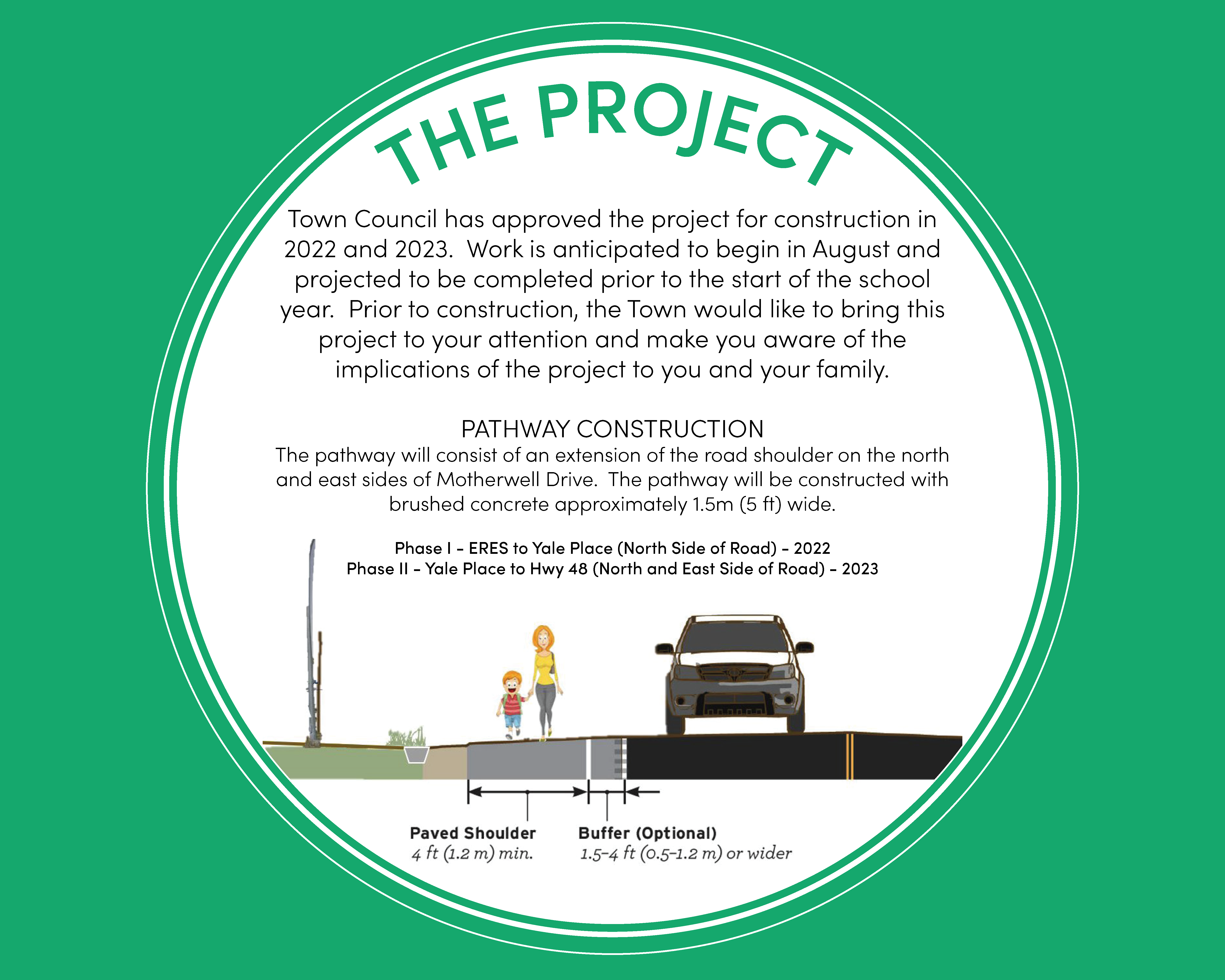
Phase III – Ramm Avenue
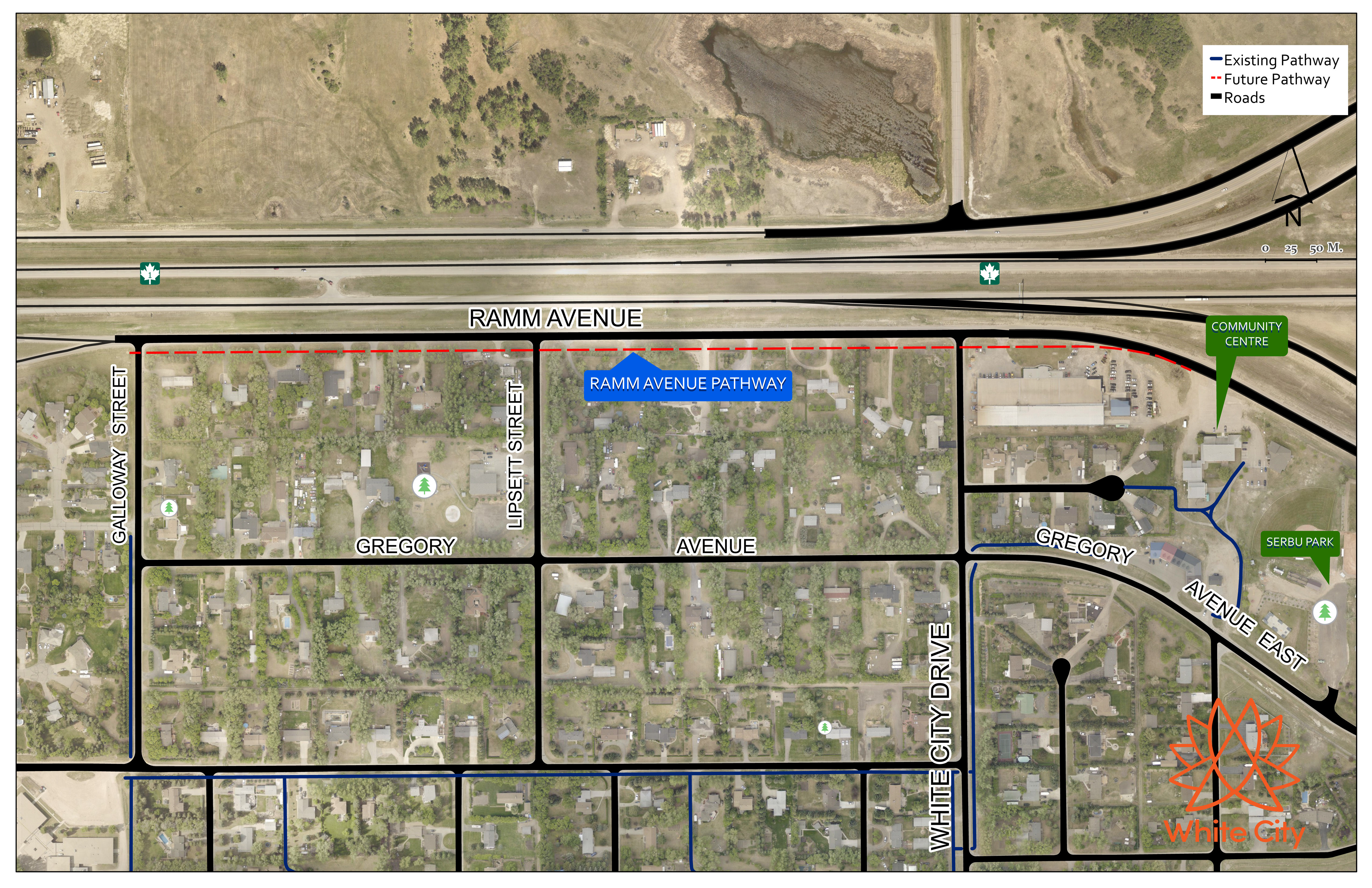
Ramm Avenue, Gregory Avenue near Highway 48, and White City Drive have the highest traffic volumes within the community. The traffic volumes along these streets experience a daily traffic volume of approximately 3,000 vehicles or greater. This traffic pattern is expected as Ramm Avenue, Gregory Avenue, and White City Drive are the main access roads into White City and the traffic volumes begin to decline along the roadways further into the residential neighbourhoods.
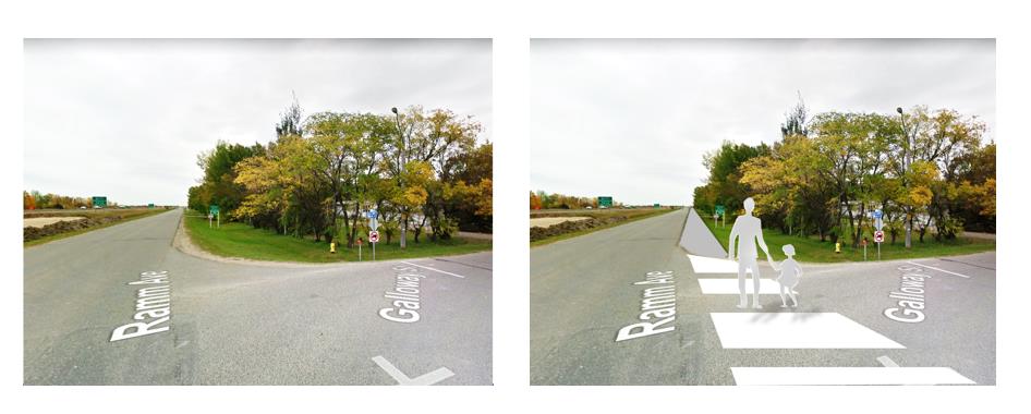
The construction of the interchange at Highway 48 required the removal of the access braid onto Ramm Avenue. This has had an effect in traffic volumes on Ramm Avenue, especially in the evening peak times. The upgrading of this section of Ramm Avenue during the highway improvements project (Regina Bypass) presented an opportunity to move the travel lanes north and dedicate the south shoulder of the road to pedestrian traffic. While this has been an improvement from the previous lack of dedicated pedestrian facilities, it can be significantly improved by constructing a paved pathway along the south side of Ramm Avenue that accommodates the existing access and drainage infrastructure and is wide enough for the exclusive use of pedestrians and bicyclists.
As the community continues to grow, Ramm Avenue will continue to see more traffic and the associated concerns related to pedestrian safety and sharing the road with vehicular traffic may become more evident. Although, with only 13 properties fronting into Ramm Avenue, this pathway will provide the much-needed pedestrian connectivity along Ramm Avenue, from the existing pathway on Galloway Street to the Community Centre and baseball fields, some of the major focal points in the community.
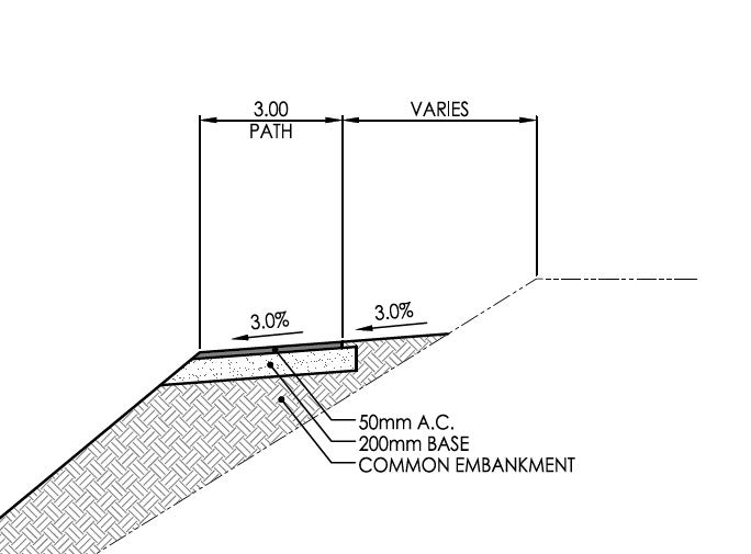
Anticipated Profile
A paved pathway area on the south side of Ramm Avenue should accommodate the existing access and drainage infrastructure and be wide enough to accommodate the horizontal operating envelope of pedestrians and bicyclists and provide a minimum of 4 ft (1.2 m) adjacent to the road edge, exclusive of any buffer or rumble strip.
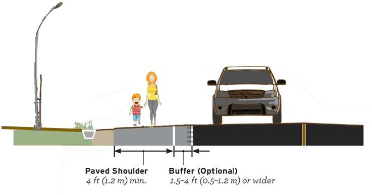
The paved pathway shall be clearly delineated and defined to discourage unnecessary encroachment by motor vehicles.
Contrasting or colored pavement materials may be used to differentiate the pathway from the adjacent travel lanes where possible and feasible. If this treatment is not feasible, a combination of rumble strips to overlap with the roadway edge line and the buffer and proper surface markings may be implemented to achieve the same goal.
Phase IV – TransCanada Trail
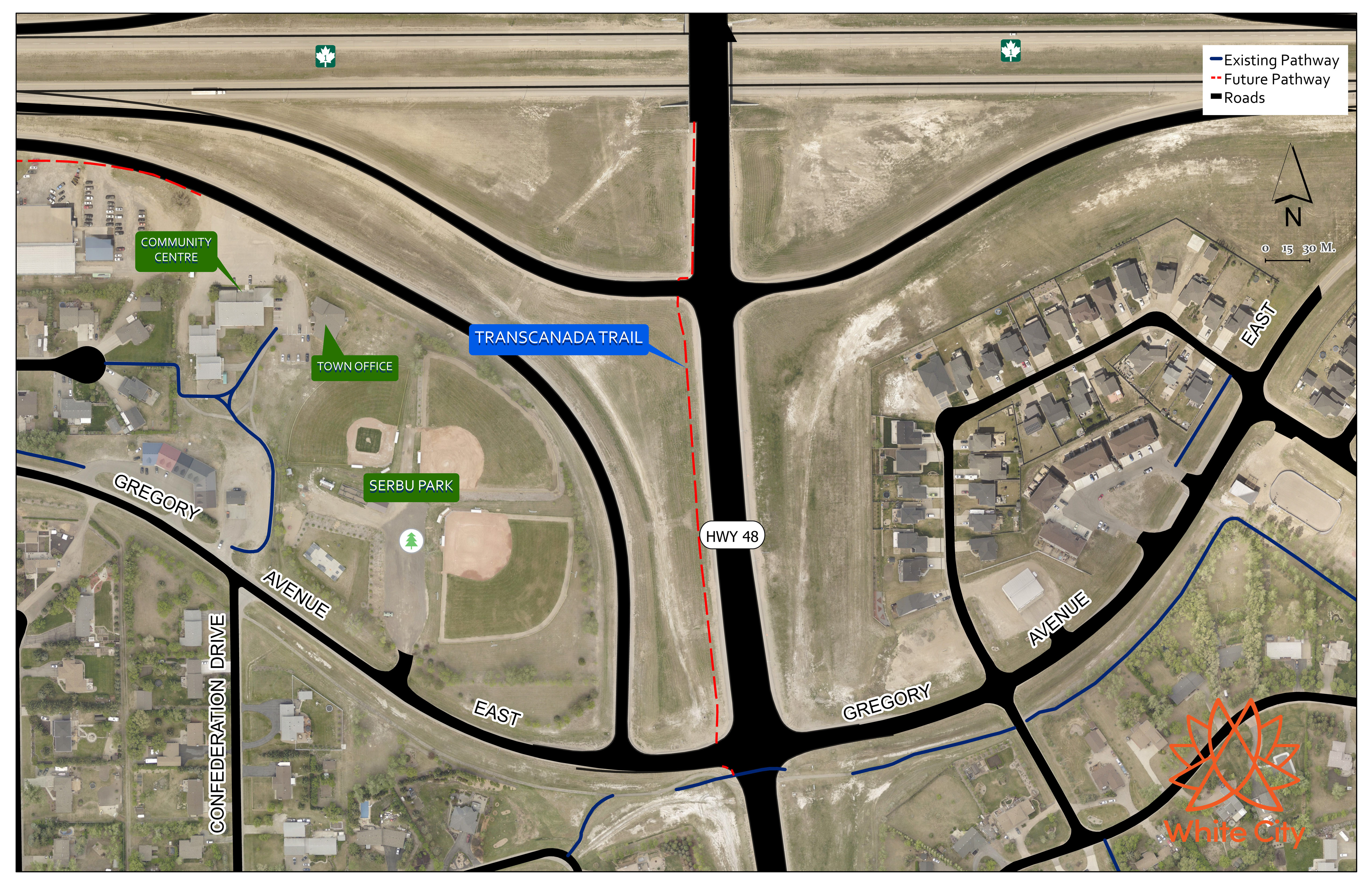
A pedestrian crossing on the overpass located at the intersection of Highway No. 1 and Highway No. 48 was completed by the partnership between the Ministry of Highways and the Regina Bypass Partners. The purpose of this pedestrian crossing is to provide for a safe pedestrian connection between the north and south of Highway No. 1. The trail, when completed will be part of the nationwide TransCanada Trail and a direct connection to the White Butte Trails Recreational Area.
While the pedestrian crossing has been completed, the connection remains closed due to the lack of connectivity to existing pathways and trails in both sides of Highway No. 1.
Future legs of the trail will connect to major parks and recreation areas in the region, with the nearby communities requiring signage and painted crosswalks on the pavement to ensure pedestrian safety. Swing gates and/or bollards will be strategically placed to support the walking and cycling activities targeted and deter any motorized vehicles from traveling through the trail.
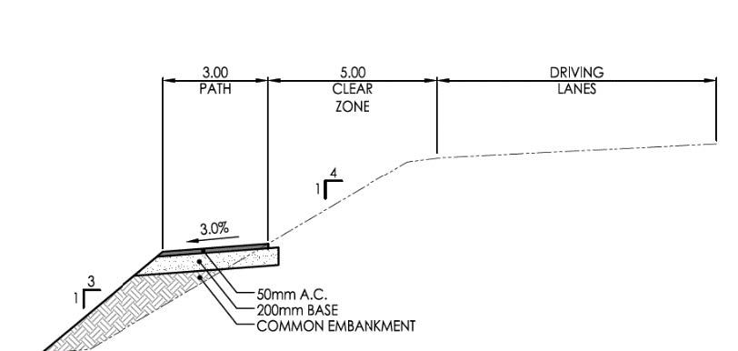
The proposed leg of the trail on this report includes only that portion of the trail that provides a connection from the pedestrian crossing at the overpass to the existing pathway on Gregory Avenue.
Anticipated Profile
Due to the high traffic count in the area, and given the major highways and access roads this trail is part of, safety is a key consideration. Stantec was engaged to provide trail design and engineering plans for legs of the trail north and south of the pedestrian crossing. Stantec recommended a 3-metre wide asphalt pathway offset from the traveling lanes and, for the most part, constructed on the side slope next to Highway No. 1 and Highway No. 48.